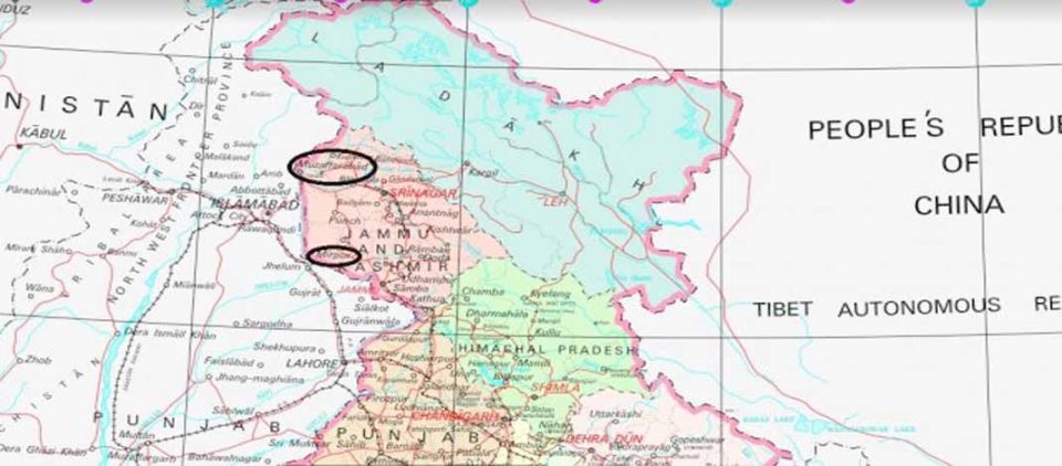
A new map of India has been released. Union Home Ministry has release it. In this, after the removal of Section 370, especially from Jammu and Kashmir, a new map has been released to divide into two parts of Jammu and Kashmir. The biggest feature in this is that the districts of Pakistan occupied Kashmir Muzaffarabad, Mirpur, Gilgit have been shown in India. Let us tell that on the recommendation of Parliament, the President has effectively abolished Article 370 of the Indian Constitution and approved the Jammu and Kashmir Reorganization Act, 2019. Under the leadership of Prime Minister Narendra Modi and under the supervision of Union Home Minister Amit Shah, on 31 October 2019, the state of Jammu and Kashmir has been reorganized as the new Union Territory and the new Union Territory of Jammu and Kashmir.
The new Union Territory of Ladakh consists of two districts namely Kargil and Leh. The rest of the former states of Jammu and Kashmir are in the new union territory of Jammu and Kashmir. In 1947, the former state of Jammu and Kashmir had the following 14 districts – Kathua, Jammu, Udhampur, Reasi, Anantnag, Baramulla, Poonch, Mirpur, Muzaffarabad, Leh and Ladakh, Gilgit, Gilgit Wazarat, Chilhas and tribal areas. By 2019, the former government of Jammu and Kashmir had reorganized the areas of these 14 districts into 28 districts. The names of the new districts are as follows – Kupwara, Bandipur, Ganderbal, Srinagar, Budgam, Pulwama, Shupian, Kulgam, Rajouri, Ramban, Doda, Kishtiyar, Samba and Kargil.
Of these, Kargil district was carved out of the region of Leh and Ladakh district. The Leh district of the new Union Territory of Ladakh is defined in the Jammu and Kashmir reorganization (removing difficulties), the second order, 2019, issued by the President of India, which includes the districts of Gilgit, Gilhar Vazarat, Chilhas has been done. And the tribal areas of 1947, after taking out Kargil district, apart from the remaining areas of Leh and Ladakh districts of 1947.
On this basis, a map prepared by the Survey General of India surveying the new union territories of Jammu and Kashmir and Ladakh, released on 31 October 2019, along with a map of India has been released.